


The Internet of Things (IoT) continues its forward march, as companies worldwide seek to gain value from the real-time insights it provides. Strategy Analytics estimates 22 billion IoT devices were connected at the end of 2018, with enterprise IoT accounting for more than half. IDC anticipates that number will nearly double, to 41.6 billion, by 2025, generating 79.4 zettabytes (ZB) of data.
As part of an IoT solution, accurate location capabilities have become an important business driver for many organizations. From improved monitoring and managing key assets to providing a deeper understanding of the behavior of employees and customers, the benefits delivered by location capabilities are helping companies evolve and move their businesses forward.
See also: What’s Ahead for the RTLS Market in the Coming Months?
Value for Many Industries
For example, location is helping companies across dozens of vertical markets:
- In manufacturing and warehouse environments, understanding where workers and equipment are helps with worker safety and collision avoidance
- In sports, understanding the relative location of players and equipment, such as hockey pucks and soccer balls, is essential for improving variables like coaching through data analysis, characterizing game dynamics, and isolating specific events using real-time tracking and data analytics
- In healthcare, location helps companies drive better patient outcomes. For example, knowing precisely where the nearest crash cart is helps patients receive faster treatment in emergencies; location also helps hospitals ensure compliance with sanitary regulations as movement of hospital and medical staff can be tracked
- In construction, being able to locate a valuable piece of equipment quickly on a large dig site saves time that can be spent on other tasks
- In supply chain and logistics, quickly determining the location of specific pallets in a crowded auto parts warehouse, for example, helps ensure accuracy in order fulfillment
As the list of applications where location can be used to help businesses lower costs and improve efficiencies grows, Bluetooth® has emerged as a technology of choice for location.
To help drive interoperability across the location-based services (LBS) market, the Bluetooth Special Interest Group (Bluetooth SIG) in January announced a new direction-finding feature as part of version 5.1 of the Bluetooth Core Specification. Although companies already have Bluetooth-based solutions in the market, the new release formalizes the addition of directional capabilities to Bluetooth proximity solutions. The goal is to provide improved accuracy for Bluetooth-based real-time location systems (RTLS).
How Accurate is Accurate Enough?
One of the big conversations surrounding location is accuracy—how precise do location capabilities need to be? Within a meter? Centimeters? The answer, of course, depends on the use case. For example, for real-time applications such as tracking fast-moving players and equipment in a sports environment, or for worker safety and collision avoidance applications in warehouse environments, precise location information is required within a dozen centimeters. In a logistics environment, where determining the location of a specific pallet or container is a key use case, accuracy within a few meters is likely good enough.
In most IoT use cases, however, it’s the combination of accuracy and delay where value is truly delivered.
Location can be complex because of the physical infrastructure present in many of these environments—concrete walls and floors, steel support beams and other infrastructure often causes interference with wireless signals and therefore makes determining location with any sort of location difficult.
The new Bluetooth direction-finding feature, however, takes infrastructure into consideration with two methodologies that help mitigate these losses, lower the complexity of the system architecture, and improve location capabilities: the Angle of Arrival (AoA) and Angle of Departure (AoD) methodologies, which each use angular direction estimation to determine positioning.
Angle of Arrival (AoA)
AoA is a network-centric solution in commercial use today across a wide range of industries and use cases, from asset tracking and safety applications in industrial industries like manufacturing, oil & gas and logistics, to productivity use cases in smart buildings and smart hospitals.
In the AoA methodology, a tag or smartphone—or virtually anything with a Bluetooth transmitter—is tracked by its position. Each device uses a single antenna to make its location available to the location service application through the transmission of direction finding-enabled packets. A multi-antenna device (aka Locator) receives the device’s radio signal and pre-processes the data for angular estimation. The data is then sent to a positioning engine, which further processes the data coming from one or many Locators and it computes the location coordinates of the tag. If needed, the location coordinates can be delivered back to the transmitting device, allowing it to display its own location.
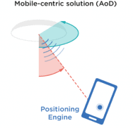
Angle of Departure (AoD)
With AoD, the intelligence is built into the device itself, such as a smartphone, a tablet, or a robot. Each device has a single antenna and directly runs the positioning engine. The device receives the radio signal transmitted by the multi-antenna device (the Locator).
In this mobile-centric architecture, power consumption is on the device side because devices like smartphones can be easily recharged frequently. In AoD, the locators might be configured as a low-power device that could be battery-operated for several years, similarly to tags in AoA systems, which are usually designed to have long battery life. Because the devices are smart and only few active transmitting devices (Locators) are needed to cover the tracking area, AoD is most appropriate for consumer-type applications (see Diagram 1)
AoD is still in its early stages, but because it enables a broad range of new precision location services for the massive consumer market, industry developments are being scrutinized carefully.
AoD may soon start gaining traction in automated guided vehicle (AGV), robotics and AI use cases where the moving object has the capability to compute its own location in real time. For AoD to find success, it will require the participation of the software OS and hardware ODM providers, such as Apple and Google, who will incorporate AoD into future mobile devices. Much work also needs to happen on the interoperability front so that multiple smartphone brands and models can receive Bluetooth signals from Locators created by different hardware vendors.
AoA and AoD Together?
AoA and AoD are not mutually exclusive; when properly designed, the Locator can carry out both AoA and AoD operations simultaneously. This makes the AoA and AoD methodologies a powerful combination for enabling a large number of use cases—all utilizing the same infrastructure device. For example, it can be used for tracking tags at the same time it enables mobile devices to autonomously compute their own location. Locators are mounted in the environment that is being monitored and used as AoA/AoD enablers.
For AoA, the Locators receive the signal transmitted by tags or phones. The whole system can be thought of as a single-input multiple-output (SIMO) system, where a single antenna tag transmits a signal and a multi-antenna device receives it. For AoD, the Locators transmit the signal using a multi-antenna radio interface and the mobile device receives it via a single antenna. In such cases, the whole system can be thought of as a multiple-input single-output (MISO) system, where multiple antennas transmit and a single antenna receives the signal.
The release of the direction finding feature of the Bluetooth 5.1 specification has created significant industry interest in real-time location capabilities. It defined the radio interface up to low-level IQ data samples. However, the specification did allow individual RTLS vendors to interpret the location system architecture themselves and build additional features and capabilities on top of the standard. A few have already successfully done so using IQ data combined with their own algorithms, software tools, and positioning engine.
The IoT continues to scale on the enterprise and industrial markets. Location is becoming a key business enabler, helping companies reduce costs and become more efficient. When AoD is ready to scale with the participation of the software OS and hardware ODM providers, the location capabilities in the consumer market will see significant growth as well. Open, flexible RTLS are key to helping both markets reach their true potential.