


People have used maps for over 5,000 years. Often considered artwork instead of reference documents, the first maps simply depicted points of interest and didn’t consider scale or orientation.
Mapping has come a long way since its rudimentary beginnings. Now laser-precise and nearly ubiquitous since the development and popularization of GPS technology, modern maps go far beyond outlining outdoor attractions. Today’s burgeoning mapping technology plots out previously uncharted territory: the indoors.
The indoor mapping space is valued at $8.8 billion and is expected to increase, with projections estimating the global indoor navigation market will reach $24 billion by 2027. Maps have evolved beyond wayfinding tools into sophisticated, multi-use solutions integrated with other technologies for many different use cases.
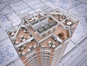
Also known as digital twins, indoor maps digitally reconstruct actual physical spaces using real-time, live data while looking and behaving like their tangible equivalents. Though integrating new technologies may come with some hesitations — maybe you’re worried about the cost of such a project or doubting its ROI — you should consider the following five key factors before designing and launching an indoor map for your facility.
See also: 3 Data-Driven Content Marketing Trends Shaped by COVID
Before you start your indoor map
1) Functions
No matter the industry, indoor maps help solve problems. Airport travelers can determine how long they need to get to their boarding gate. Students and visitors can easily find buildings and classrooms on sprawling college campuses. In a hospital, an indoor map can outline an efficient path to a room or ward. At a stadium, fans can use the map to book a parking space and find their seats. Maps give first responders an overview of a building’s entrances and exits.
When considering creating an indoor map for your space, determining its main purpose will help you identify which features to highlight. Are you hoping to use it to improve employees’ experiences? Do you want to elevate your operational processes? Will it help enhance your facility’s safety protocols and procedures? An indoor map can help with all of those goals and more.
2) Live data
The most valuable indoor maps use live data collected and combined from already existing systems. This live data provides up-to-the-minute imaging of your facility. You can use dynamic integration to aggregate data otherwise trapped in disparate systems, making it more accessible and easier to use.
Even if your facility implements changes regularly, live data will generate an accurate and updated map. Maybe you’re getting rid of excess office space because your workforce has gone hybrid/remote or scaling your business and need a few additional floors in a building. No matter the case, live data immediately actualizes those modifications on your map. You can also use that data to optimize the safety, efficiency, and utilization of your spaces.
Manual data updates, on the other hand, are a costly time suck. Whether you’re adding points of interest on your map or removing outdated information, doing so by hand introduces the possibility of human error, especially if your organization is scaling. Beyond the possibility of errors, each change has an associated cost, and those expenses compound quickly.
Consider using a third-party indoor mapping platform to save time and money. This platform should seamlessly integrate with your current systems, use live data, and scale with your business. Though start-up costs are associated with implementing the platform, overall costs are less than those generated by manual updates and maintenance.
3) Security and sustainability efforts
An easily-integrated indoor mapping platform also improves existing security and sustainability efforts. For example, you can adjust the lighting and temperature in less frequently used spaces to reduce energy costs while decreasing your carbon footprint.
Further, a map using live data will always be updated, supporting safety initiatives in an emergency. If your facility runs a fire drill, the building occupants can use the map to navigate safely out. The map can show locations of safety equipment such as AEDs and fire extinguishers. You can use data from your map to decide where to station security personnel or where to set up security cameras.
4) ADA applications
The United States passed the Americans with Disabilities Act (ADA) in 1990 to ensure disabled people have the same opportunities in day-to-day life as non-disabled individuals, including navigating businesses where they shop. Indoor maps empower people with disabilities to be independent while promoting inclusivity and accessibility.
With so many diverse disabilities, there is no universal accessibility solution. However, indoor mapping offers a solution for some common accessibility concerns. Mapping can promote independence for visually- or hearing-impaired people who can use the maps on their personal devices to conduct their business with less reliance on others.
People with mobility issues can also use indoor maps to help them navigate independently. These maps point the way to wheelchair-accessible routes — like ramps and elevators — which are sometimes tucked away and difficult to find. In fact, an indoor map can even include a feature that allows users to select “accessible routes,” making these paths even easier to locate.
5) User objectives
Another factor to consider during the planning and design stage? The map’s intended users. For example, if you have an expansive corporate office, some employees would benefit from an indoor map in many ways, including:
- Finding colleagues in real-time for project and presentation collaboration.
- Enabling new or hybrid employees or guests who may not be familiar enough with your spaces to navigate without getting lost or having to ask for directions.
- Equipping everyone with an overview of the space, including available and occupied spaces and co-workers’ locations.
In lieu of assigning specific desks to specific employees, many large organizations use “hot desks” or “hoteling.” While finding a free desk only takes a few minutes each day, the time spent looking for an unoccupied space adds up to two weeks over a year!
Indoor maps use integrated technologies to help employees find and book an open desk or conference room. The map can give information about spaces, like the number of occupants, including video-conferencing equipment and even its current temperature.
A final word about building indoor maps
People still use indoor maps for navigation. Thanks to technological advances and integrations, uses have evolved far beyond wayfinding. Indoor maps complement workplace solutions to improve employee experiences and productivity, benefitting all organizations. From accessibility solutions to leveraging data insights, the technology’s use cases across industries are nearly endless.